Time: 81:30
Distance: 11.5 mi.
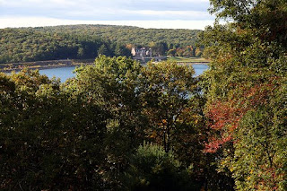
I headed to the southern tip of the Quabbin Reservoir to explore the trails/roads in "Quabbin Park" near the Winsor Dam. I looked at both the topo map and Massachusetts DCR map of the area and figured there had to be more trails than I saw on either one. Having no real idea where I was headed made for a bit of a disjointed run, but it was fun to fly through the woods with no idea in particular where I was going to pop out. The run took me out on some trails, I ran right up to the tower at the top without even trying to get there. I finished up running across the top of the dam past the visitor's center.
The Quabbin Tower, which overlooks the southern portion of the reservoir, as well as parts of Belchertown, Ware and Palmer
The Winsor Dam (left) and visitor's center (center)
Again, despite a very hilly run, my right hamstring was in okay shape throughout. It was
9 years ago

No comments:
Post a Comment