Showing posts with label quabbin. Show all posts

Tuesday, November 11, 2008

Quabbin Park

Time: 81:30
Distance: 11.5 mi.

I headed to the southern tip of the Quabbin Reservoir to explore the trails/roads in "Quabbin Park" near the Winsor Dam. I looked at both the topo map and Massachusetts DCR map of the area and figured there had to be more trails than I saw on either one. Having no real idea where I was headed made for a bit of a disjointed run, but it was fun to fly through the woods with no idea in particular where I was going to pop out. The run took me out on some trails, I ran right up to the tower at the top without even trying to get there. I finished up running across the top of the dam past the visitor's center.


The Quabbin Tower, which overlooks the southern portion of the reservoir, as well as parts of Belchertown, Ware and Palmer


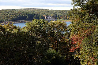
The Winsor Dam (left) and visitor's center (center)

Again, despite a very hilly run, my right hamstring was in okay shape throughout. It was

Thursday, September 11, 2008

Quabbin Trails

Time: 71:20
Distance: 10 mi.

I drove back up to the trails near the Quabbin Reservoir where I ran early last week. I went on a left fork of the same trail which took me uphill faster than I expected and the trail ran up to Wendell Road. I ran to the right hoping to meet up with the run that I did out here previously, but up to 37 minutes didn't find it (which isn't surprising, after looking at the map). This was hillier than expected and than my sore calves would have liked. I definitely need to run very easy tomorrow.

Monday, September 1, 2008

Quabbin Trails

Time: 64:40
Distance: 10 mi.
Map (approximate)


Near the north west corner of the Quabbin Reservoir in Shutesbury there are a few miles of bicycle access trails. While I had heard of these before, I have never explored them. Without knowing them at all, an out-and-back run was in order, but I could have easily gone farther and gotten lost, which would have been nice. The trails are fairly wide and well-maintained in most areas and, for some reason, are in some places listed as real roads on Google Maps. I took New Boston Rd. from Cooleyville Rd. up to Rockwell Hill Rd. and then came back, according to this MA DCR map.

I ran decently hard out in 34:00 and then hammered back in around 30:00. Honestly, this could easily have been over 10 miles.